

The innovation that GreenWaterDrone proposes, is about the way of measuring and applying the Crop Water Stress index (CWSI), combining the advantages of the focused and short distance measurement of terrestrial infrared sensor systems, with the possibility of efficient low-cost large-scale coverage of satellite telemetry systems. It is based on the use of unmanned flying drones equipped with the appropriate equipment for the direct measurement of foliar temperature with spatial accuracy that can be dynamically adjusted to the density and heterogeneity of the crop and is used in real time, via wireless networking for planning irrigation dynamically and crop monitoring on small / large scale. Particular characteristics of the innovative approach of GreenWaterDrone are presented below:
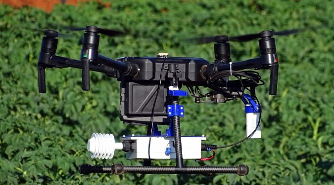
- Use of an infrared sensor: compared to current aerial thermography methods, no thermographic camera is used for temperature measurement with image recording and processing, but a light and low-cost infrared (IR) sensor that records directly in the appropriate pattern (data logger), significantly improving the accuracy, the processing load per measurement and the cost of the solution.
- High & Dynamic Spatial Measurement Analysis: The drone can be found a few meters above the foliage, in a stable spatial position for a short time, making focused repetitive measurements possible. The target surface is determined by the density of the crop (soil cover) and the capture is guided by a visual monitoring system to minimize the possibility of failure.
- Heterogeneous Crop Support: Temperature measurement can be carried out on a single flight for heterogeneous vegetation, by recording the spatial coordinates for each set of measurements, so that different crops can be monitored in the coverage area.
- Dynamic Irrigation Control Possibility: Temperature measurements are recorded in real time in the DB and are combined with micrometeorological data and calibration data from terrestrial sensors (only necessary in the first stage), to calculate CWSI and immediate irrigation alert. The alert can be combined with the automatic activation of the irrigation system and - if supported by a partially functioning articulated system - implemented at selected points.
- Dynamic Crop Surveillance: The system captures the implementation of irrigation (thermography), detects and records damage / malfunctions / irrigation system losses and the effects of extreme natural phenomena, or other anthropogenic disasters on the crop (visual recording).
- Gradation of the system application: The system can be applied incrementally over large areas, provided that there are sufficient calibrated crop samples in the cover area.